Embalse Potrerillos

Is Embalse Potrerillos worth visiting?
A mountain lake an hour from Mendoza, with a small village, rafting on the Mendoza River and kayaking against an Andean backdrop.
At a glance
| Type | Natural attraction |
|---|---|
| Department | Luján de Cuyo |
| Distance from Plaza Independencia | 34 km (straight line) |
| Opening hours | Confirm before going: we could not find current official hours. |
| Coordinates | -32.96303, -69.19662 |
About Embalse Potrerillos
Potrerillos reservoir is the closest mountain escape from the city: a lake about 7 km long and 1,500 hectares in size on the Mendoza River, ringed by hills and some 70 km from the capital. Beside it sits the village of Potrerillos, with cabins, restaurants, campsites and adventure operators, and the Mendoza River is home to some of the most popular rafting in the country.
It works as a day trip or an overnight stay. The lake is best enjoyed by kayak, from the shore or at the viewpoints rather than by swimming: Mendoza's reservoirs ban swimming outside buoyed areas with lifeguards, and there have been rescues in unauthorised spots. In summer and on long weekends the shore gets crowded, so go on a weekday if you can.
Local tip
From the city, drive out on RP 82 (via Cacheuta) and back on RN 7: you'll see the river and the dam from two angles without retracing your route.
Practical guide
Before you go
- Swimming is banned outside buoyed areas with lifeguards; there have been rescues in unauthorised spots.
- No boating from 9 pm to 7 am, and everyone on board must wear a life jacket.
- Park away from the shoreline, as the province asks, and follow the lakeside signs.
- Fires only in authorised spots; take all your rubbish with you.
What to do
- Raft the Mendoza River, with beginner sections and more demanding ones
- Kayak on the reservoir with an operator
- Wander the village and eat at one of its restaurants
- Go hiking, horseback riding or mountain biking in the hills
- Combine it with the Cacheuta hot springs, about 12 km away
- How long
- A full day; one or two nights to combine rafting, hot springs and mountains.
- Who it suits
- Families, groups and adventure lovers. If you're after a beach where you can swim freely, this isn't it.
- Best time to go
- October to March, snowmelt raises the river and rafting is at its liveliest. The rest of the year suits quiet outings and walks.
- Opening hours
- Confirm before going: we could not find current official hours.
- Admission and prices
- Free access to the reservoir and village. Rafting, kayaking and other activities are paid separately to operators.
- Booking
- Recommended · For rafting and accommodation in summer and on long weekends.
Tours and activities that go here
See all →
High Andes day trip: Aconcagua and Puente del Inca
A full day up Route 7 to the foot of Aconcagua, taking in Potrerillos, Uspallata, Puente del Inca and, in summer, the Christ the Redeemer statue.
See activity →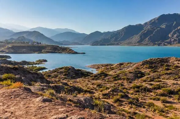
Potrerillos and Cacheuta half-day trip
A half day in the Andean foothills near the city: the Potrerillos reservoir, the Mendoza River valley and the spa village of Cacheuta.
See activity →
Whitewater rafting on the Mendoza River
Raft the Mendoza River rapids at Potrerillos, an hour from the city: the province's classic water adventure.
See activity →How to get there
From Mendoza, take RN 40 and RN 7 towards Chile, then RP 89 to the dam: about 70 km, roughly 1 hour. The scenic alternative is RP 82 via Cacheuta. Regular buses run from Mendoza's bus terminal.
Coordinates: -32.96303, -69.19662
Weather in Embalse Potrerillos
Compare with similar mountains and nature
| Place | Department | To downtown | Hours | Contact |
|---|---|---|---|---|
| Embalse Potrerillos | Luján de Cuyo | 34 km | — | — |
| Cerro Aconcagua | Las Heras | 112 km | — | |
| Parque Provincial Aconcagua | Las Heras | 106 km | Published | |
| Cañón del Atuel | San Rafael | 229 km | — | — |
| Cerro de la Gloria | Capital (Mendoza City) | 4.2 km | Published | — |
hours published · phone · website · WhatsApp
What else is nearby
Frequently asked questions
Where is Embalse Potrerillos?
In Luján de Cuyo, Mendoza, Argentina, 34 km from Plaza Independencia. Coordinates: -32.96303, -69.19662.
How much time do you need for Embalse Potrerillos?
A full day; one or two nights to combine rafting, hot springs and mountains.
How much does it cost to visit Embalse Potrerillos?
Free access to the reservoir and village. Rafting, kayaking and other activities are paid separately to operators. (checked on October 8, 2026; confirm before going).
Do you need to book Embalse Potrerillos?
Recommended. For rafting and accommodation in summer and on long weekends.
When is the best time to visit Embalse Potrerillos?
October to March, snowmelt raises the river and rafting is at its liveliest. The rest of the year suits quiet outings and walks.
How do I get to Embalse Potrerillos?
From Mendoza, take RN 40 and RN 7 towards Chile, then RP 89 to the dam: about 70 km, roughly 1 hour. The scenic alternative is RP 82 via Cacheuta. Regular buses run from Mendoza's bus terminal.
What is near Embalse Potrerillos?
Oficina de Turismo (220 m), Posta Potrerillos (280 m), Cabañas Soledad (300 m).
Hours and prices change: confirm before going. Report a change · Sources
Listed in
You may also like
Cerro Aconcagua
The roof of the Americas, almost 7,000 m high: seeing it head-on from the Horcones valley is one of Mendoza's signature views.
See details →Parque Provincial Aconcagua
An easy trail to Laguna de Horcones with Aconcagua as the backdrop, and the gateway for treks and summit attempts.
See details →Cañón del Atuel
A gravel road that winds between colourful cliffs and odd rock formations, following the Atuel River from Valle Grande to El Nihuil.
See details →Cerro de la Gloria
The best viewpoint over the city, crowned by a huge bronze monument telling the story of San Martín's crossing of the Andes.
See details →