Cerro Aconcagua
Is Cerro Aconcagua worth visiting?
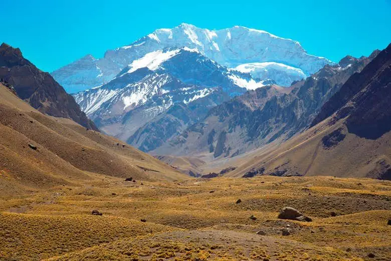
The roof of the Americas, almost 7,000 m high: seeing it head-on from the Horcones valley is one of Mendoza's signature views.
At a glance
| Type | Natural attraction |
|---|---|
| Department | Las Heras |
| Distance from Plaza Independencia | 112 km (straight line) |
| Opening hours | Confirm before going: we could not find current official hours. |
| Coordinates | -32.65315, -70.01196 |
| Web | mendoza.gov.ar/aconcagua |
About Cerro Aconcagua
Aconcagua is the highest mountain in the Americas and the tallest on Earth outside the Himalayas and the Pamirs, at roughly 6,960 metres. You don't need to be a climber to enjoy it: from the Horcones entrance on Route 7, the snowy summit rises at the far end of the valley, and on a clear day that view alone is worth the drive.
For most visitors this is a look-and-linger experience: walk the Laguna de Horcones trail, take photos and take in the sheer scale of the Andes. Climbing it is a different matter, requiring an ascent permit, several days of acclimatisation and high-altitude experience (see the Aconcagua Provincial Park entry for details). Clouds can hide the peak within minutes, and in winter the road is often closed by snow, so check the forecast and road status before you set off.
Local tip
Leave Mendoza early: you'll arrive while the morning is clearest and still have time to stop at Puente del Inca on the way back.
Practical guide
Before you go
- In winter Route 7 can close due to snow or wind, and snow chains are mandatory: check road status before leaving.
- After snowfall, the Horcones trail may close for a few days or open only partly.
- Altitude: if you get a bad headache, nausea or shortness of breath, go down and don't climb higher.
What to do
- See the summit head-on from the Laguna de Horcones trail
- Photograph it in good light: leave early so you have time if clouds roll in
- In summer, add a day trek deeper into the valley (permit required)
- Pair it with Puente del Inca, just a few kilometres away
- How long
- Full day from Mendoza (about 3 hours' drive each way)
- Who it suits
- Anyone driving Route 7, kids included. Going for the summit is only for trained, acclimatised climbers with a permit.
- Best time to go
- November to April, when the road is more reliable and the park is in its main season. In winter it's spectacularly snowy, but you depend on Route 7 and the Horcones access being open.
- Opening hours
- Confirm before going: we could not find current official hours.
- Admission and prices
- Viewing it from the road is free. The Horcones trail requires a park ticket: ARS 10,000 per person per day (2025-2026 rate, Decree 2322/25). Climbing requires a separate permit.
- Booking
- Not needed · Nothing needed to see it from the road. If you walk the Horcones trail, the ticket must be booked and paid online beforehand.
- Parking
- To see it up close, park at the Horcones car park in front of the park base (see the Aconcagua Provincial Park entry).
- Accessibility
- Viewing it from the entrance takes no effort, but you're above 2,700 m: walk slowly, drink water and watch for headaches or dizziness.
Tours and activities that go here
See all →
High Andes day trip: Aconcagua and Puente del Inca
A full day up Route 7 to the foot of Aconcagua, taking in Potrerillos, Uspallata, Puente del Inca and, in summer, the Christ the Redeemer statue.
See activity →
Day hike to Confluencia, Aconcagua
A day hike to Confluencia, Aconcagua's first camp at about 3,400 m: the most accessible way to set foot in the park.
See activity →How to get there
From Mendoza take Acceso Este and Route 7 towards Chile, through Potrerillos and Uspallata, to the Horcones entrance just past Puente del Inca: about 185 km, roughly 3 hours. Without a car, full-day High Andes tours are the usual option.
Coordinates: -32.65315, -70.01196
Weather in Cerro Aconcagua
Paso Cristo Redentor status
Compare with similar mountains and nature
| Place | Department | To downtown | Hours | Contact |
|---|---|---|---|---|
| Cerro Aconcagua | Las Heras | 112 km | — | |
| Parque Provincial Aconcagua | Las Heras | 106 km | Published | |
| Cañón del Atuel | San Rafael | 229 km | — | — |
| Cerro de la Gloria | Capital (Mendoza City) | 4.2 km | Published | — |
| Reserva Natural La Payunia | Malargüe | 412 km | — |
hours published · phone · website · WhatsApp
What else is nearby
Frequently asked questions
Where is Cerro Aconcagua?
In Las Heras, Mendoza, Argentina, 112 km from Plaza Independencia. Coordinates: -32.65315, -70.01196.
How much time do you need for Cerro Aconcagua?
Full day from Mendoza (about 3 hours' drive each way)
How much does it cost to visit Cerro Aconcagua?
Viewing it from the road is free. The Horcones trail requires a park ticket: ARS 10,000 per person per day (2025-2026 rate, Decree 2322/25). Climbing requires a separate permit. (checked on October 8, 2026; confirm before going).
Do you need to book Cerro Aconcagua?
Not needed. Nothing needed to see it from the road. If you walk the Horcones trail, the ticket must be booked and paid online beforehand.
When is the best time to visit Cerro Aconcagua?
November to April, when the road is more reliable and the park is in its main season. In winter it's spectacularly snowy, but you depend on Route 7 and the Horcones access being open.
How do I get to Cerro Aconcagua?
From Mendoza take Acceso Este and Route 7 towards Chile, through Potrerillos and Uspallata, to the Horcones entrance just past Puente del Inca: about 185 km, roughly 3 hours. Without a car, full-day High Andes tours are the usual option.
What is near Cerro Aconcagua?
Cólera (1.9 km), Berlín (1.9 km), Nido de Condores (2.4 km).
Hours and prices change: confirm before going. Report a change · Sources
Listed in
You may also like
Parque Provincial Aconcagua
An easy trail to Laguna de Horcones with Aconcagua as the backdrop, and the gateway for treks and summit attempts.
See details →Cañón del Atuel
A gravel road that winds between colourful cliffs and odd rock formations, following the Atuel River from Valle Grande to El Nihuil.
See details →Cerro de la Gloria
The best viewpoint over the city, crowned by a huge bronze monument telling the story of San Martín's crossing of the Andes.
See details →Reserva Natural La Payunia
One of the world's most striking volcanic fields: black lava flows, colorful craters and guanacos roaming the steppe.
See details →